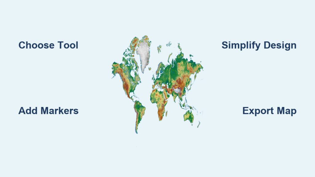
Creating a custom map on your computer is now easier than ever, even if you’ve never used design software. The best way to make a map on the computer involves choosing the right tool for your purpose—whether it’s a simple locator map for a business, a fantasy world for a novel, or a data-driven visualization for research. With platforms like Canva, Google My Maps, ArcGIS, and National Geographic MapMaker, you can build professional-quality maps in minutes using intuitive interfaces, drag-and-drop tools, and ready-made templates. No cartography degree required.
This guide breaks down the top tools, step-by-step workflows, design best practices, and common pitfalls so you can create clear, engaging maps tailored to your audience. Whether you’re a teacher, traveler, marketer, or storyteller, you’ll learn how to turn your idea into a functional, visually appealing map—right from your desktop.
Choose the Right Tool for Your Map Project

Canva: Create Stylish Maps Without Design Skills
Canva is the best option for users who want to make polished, shareable maps fast—especially for marketing, events, or education. Its drag-and-drop editor and vast template library let you build maps in minutes, even with zero design experience.
Why Use Canva?
• Free to use with optional premium features
• Thousands of customizable map templates (world, city, country, fantasy)
• AI-powered trip planner for travel maps
• Real-time collaboration and sharing
Best For:
• Wedding or event wayfinding maps
• Social media graphics with location tags
• Fantasy world maps for games or books
• School projects and infographics
How to Make a Map in Canva:
1. Go to Canva.com and log in
2. Search “map” in the template bar
3. Choose a template (e.g., “World Map with Markers”)
4. Customize colors, labels, and icons
5. Add text, arrows, or drawings using the Draw tool
6. Download as PNG, JPEG, or PDF
Pro Tip: Use parchment-style backgrounds and custom fonts to give fantasy maps an ancient, hand-drawn look.
Google My Maps: Build Custom Real-World Maps
Google My Maps is ideal for creating personalized, interactive maps of real locations. It’s free, easy to use, and integrates with your Google account for seamless sharing and collaboration.
Why Use Google My Maps?
• Free and accessible from any browser
• Pin locations, draw routes, and add notes
• Supports multiple layers and custom markers
• Shareable via link or embeddable on websites
Best For:
• Travel itineraries with multiple stops
• Business location finders
• Real estate listings
• Classroom geography projects
How to Create a Map:
1. Visit Google My Maps
2. Click “Create a new map”
3. Name your map and add a description
4. Add markers by clicking the pin icon and placing it on the map
5. Draw lines for routes or shapes for zones
6. Change the base map style (roadmap, satellite, etc.)
7. Share or embed the map
Visual Cue: The “Untitled layer” panel on the left lets you organize markers, lines, and shapes into categories.
Common Mistake: Adding too many pins. Stick to 5–10 key locations to keep the map readable.
ArcGIS Map Viewer: Professional Data Mapping
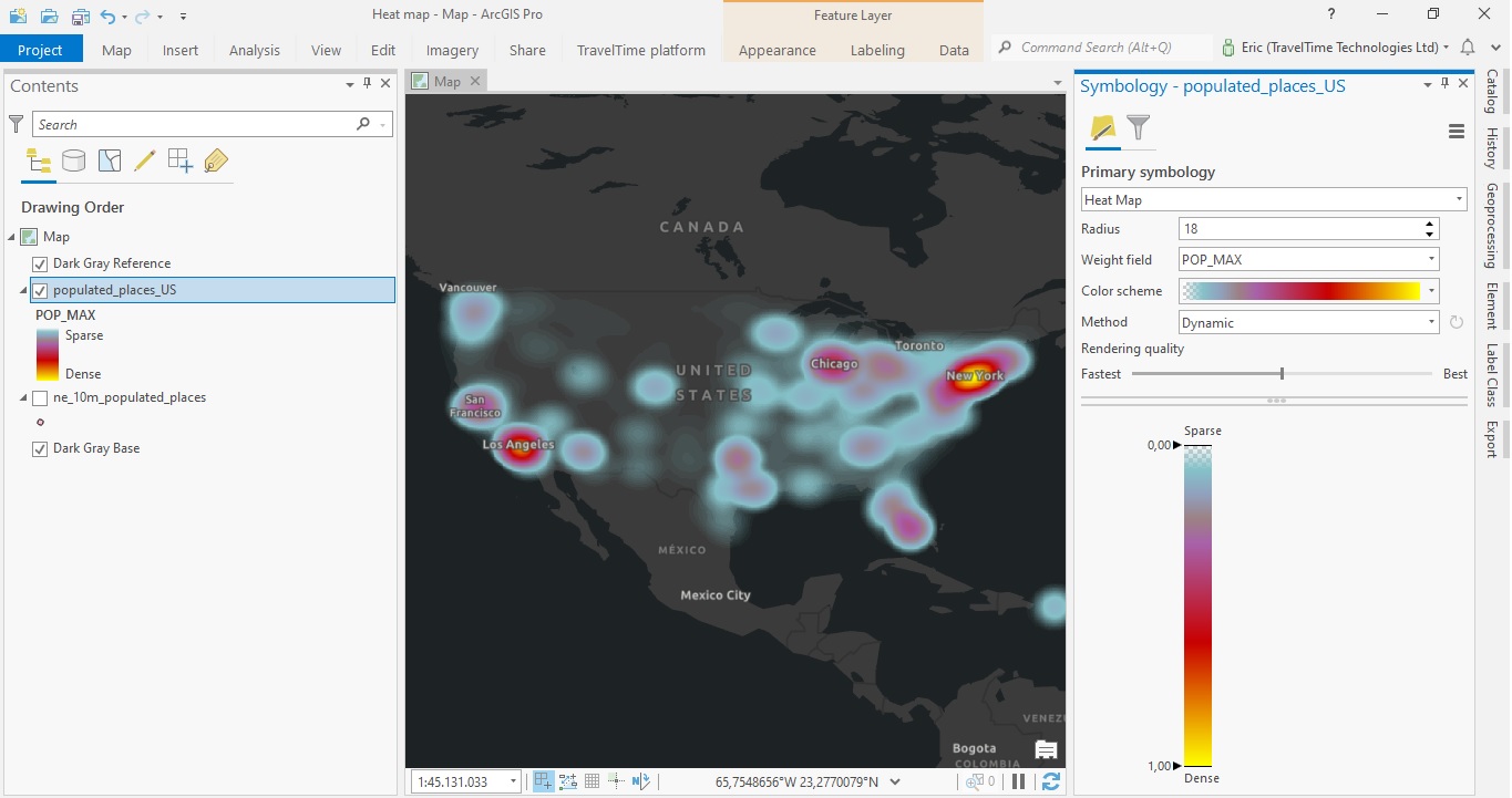
ArcGIS is the go-to tool for researchers, planners, and analysts who need to visualize complex data. It offers advanced styling, layering, and interactive features for creating story-rich, data-driven maps.
Why Use ArcGIS?
• Powerful data visualization and analysis tools
• Smart mapping with color gradients, dot density, and heat maps
• Interactive pop-ups with charts, images, and links
• Cloud-based sharing and collaboration
Best For:
• Public health or environmental research
• Urban planning and disaster response
• Academic projects with geographic data
• Interactive web maps for dashboards
Step-by-Step Workflow:
1. Choose a Basemap: Pick one that fits your audience—e.g., “Topographic” for hikers, “Dark Gray Canvas” for presentations
2. Add Layers: Import CSV files, shapefiles, or search ArcGIS Living Atlas for ready-made data
3. Style Data: Use color ramps or proportional symbols to show patterns
4. Configure Pop-ups: Add images, links, or charts to display detailed info on click
5. Save and Share: Publish to your organization or make it public
Time Estimate: 20–60 minutes, depending on data complexity.
Expert Note: Use Arcade expressions to calculate and display dynamic values—e.g., “This county has 15% higher unemployment than average.”
National Geographic MapMaker: Educational Mapping Made Easy
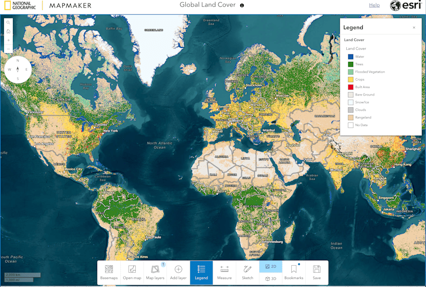
MapMaker, developed by National Geographic and Esri, is built for classrooms. It combines authoritative data with guided lessons, making it perfect for teaching geography, history, and earth science.
Why Use MapMaker?
• Trusted, accurate data sources
• Ready-made lesson plans included
• Designed for student engagement
• Free and web-based
Best For:
• Middle and high school geography projects
• Teaching ancient trade routes like the Silk Road
• Exploring natural disasters and ecosystems
• Student-led research assignments
How to Use It:
1. Go to NatGeo MapMaker
2. Choose a theme (e.g., “Volcanoes and Earthquakes”)
3. Zoom to your area of interest
4. Turn on relevant data layers
5. Annotate with text or markers
6. Take screenshots or export for reports
Classroom Tip: Assign students to trace the Silk Road and label key cities—great for visual learning.
Match Your Tool to the Map Type
Locator Maps: Help People Find a Place
A locator map shows how to get to a specific location—like your store, office, or event venue.
Best Tools: Canva, Google My Maps
Key Features:
• Pinpoint location with a clear marker
• Highlight major roads or landmarks
• Remove side streets to reduce clutter
Design Hack: In Canva, use a red pin and bold address text. Add a border to focus attention.
Wayfinding Maps: Guide Visitors Step by Step
Wayfinding maps show the journey, not just the destination—perfect for weddings, conferences, or campus tours.
Best Tools: Canva, Google My Maps
How to Build:
1. Start with a base map
2. Draw the route using arrows or colored lines
3. Add numbered stops or checkpoints
4. Include landmarks (e.g., “Next to the fountain”)
Pro Tip: For wedding invitations, use a whimsical Canva template with illustrated trees and paths.
Travel and Trip Maps: Plan Your Journey
Whether you’re backpacking through Europe or road-tripping across states, a travel map keeps your itinerary organized.
Best Tools: Canva (AI trip planning), Google My Maps
Steps:
1. Plot each destination
2. Add notes: hotel names, reservations, must-see spots
3. Color-code by day or activity
4. Share with travel companions
Time-Saving Shortcut: In Canva, use the AI trip planner to auto-generate a route based on your destinations.
Data Visualization Maps: Tell a Story with Data
Use maps to show patterns—like sales by region, population density, or election results.
Best Tools: ArcGIS, Canva (for simple charts)
How to Succeed:
• Use color gradients to show intensity (e.g., dark red = high crime rate)
• Add a legend so viewers understand the scale
• Limit to 1–2 data sets to avoid clutter
Example: In ArcGIS, upload a CSV of city populations and apply a “dot density” style—one dot = 10,000 people.
Fantasy Maps: Create Imaginary Worlds

For writers, gamers, or D&D fans, fantasy maps bring fictional worlds to life.
Best Tools: Canva, Inkscape (free), or Azgaar’s Fantasy Map Generator
How to Design:
1. Start with a blank canvas in Canva
2. Use the Draw tool to sketch continents and mountains
3. Add forests, rivers, and cities with clipart
4. Label regions with custom fonts (e.g., “The Shattered Peaks”)
5. Apply gradients for oceans and terrain
Creative Boost: Use textured backgrounds or parchment-style templates for an ancient look.
Interactive Maps: Engage Your Audience
Interactive maps let users zoom, click, and explore—perfect for websites or dashboards.
Best Tools: ArcGIS, Google My Maps (basic), Mapbox (advanced)
What Users Can Do:
• Zoom in/out
• Click markers for details
• Switch between map views (satellite, terrain)
Reality Check: True interactivity (e.g., filtering data) requires coding or advanced tools. For most users, Google My Maps’ clickable pins are sufficient.
Follow Essential Map Design Best Practices
Pick the Right Basemap
Your basemap sets the tone. Choose wisely:
• Roadmap: For directions and addresses
• Satellite: For natural features and terrain
• Topographic: For hiking or elevation
• Dark Mode: For presentations with minimal distraction
Warning: Avoid overly detailed basemaps—they compete with your data.
Manage Layers Wisely
Layers are like transparent sheets stacked on top of each other.
Do:
• Use one layer per category (e.g., “Restaurants,” “Hotels”)
• Turn layers on/off for clarity
• Name layers clearly
Don’t:
• Add more than 5 layers—maps become cluttered
• Mix unrelated data (e.g., weather and traffic)
Style for Clarity and Impact
Good styling makes your map easy to read.
Color Tips:
• Use blue for water, green for parks, gray for roads
• Stick to 3–5 colors max
• Use contrast to highlight key areas
Symbol Tips:
• Use consistent icons (all pins same size)
• Larger symbols = more important features
• Add labels only when necessary
Simplify for Your Audience
A great map shows only what’s needed.
Ask Yourself:
• Is this street relevant?
• Does the viewer need to see every building?
• Can I remove labels without losing meaning?
Rule of Thumb: If it doesn’t help the user, remove it.
Export and Share Your Map the Right Way
Choose the Best File Format
• PNG: Best for web use—high quality, supports transparency
• JPEG: Smaller file size, good for email or social media
• PDF: Ideal for printing or professional reports
Pro Tip: In Canva, download as PDF for crisper text and scalability.
Share and Collaborate Effectively
Most tools let you:
• Share via link (Google My Maps, Canva)
• Embed in websites (ArcGIS, My Maps)
• Invite collaborators (Canva, ArcGIS)
Security Note: Set sharing permissions—private, view-only, or edit access.
Avoid These Common Map-Making Mistakes
❌ Overloading the Map
Too many pins, lines, or labels confuse users.
Fix: Use layers to organize and hide non-essential info.
❌ Ignoring Scale
A map that’s too zoomed out loses detail; too zoomed in loses context.
Fix: Show a zoomed-out inset map for reference.
❌ Poor Label Placement
Labels that overlap or float in empty space hurt readability.
Fix: Manually adjust label positions—don’t rely on auto-placement.
❌ Forgetting the Legend
If colors or symbols aren’t obvious, add a legend.
Fix: Place it in a corner with clear, concise text.
Frequently Asked Questions About Making Maps on the Computer
What is the easiest way to make a map online?
The easiest way is using Canva or Google My Maps. Both are free, require no design skills, and offer intuitive drag-and-drop tools. Just pick a template, add your locations, and customize the look.
Can I make a map without an internet connection?
Most online tools require internet access. However, you can use offline GIS software like QGIS or download maps in Google Earth Pro for limited offline editing.
How do I make a fantasy map for a story or game?
Use Canva’s blank canvas and Draw tool to sketch continents, mountains, and cities. Add forests and rivers with clipart, use custom fonts for labels, and apply gradients for terrain. Parchment-style templates enhance the fantasy feel.
Can I add custom data to my map?
Yes. In ArcGIS, upload CSV or shapefiles to plot data points. In Google My Maps, import spreadsheets with addresses. Canva lets you manually add data with text and icons.
How do I make a map for a wedding invitation?
Use Canva’s wedding map templates. Add a pin for the venue, draw the route from a landmark, and include labels like “Reception at Willow Hall.” Use soft colors and decorative fonts to match your theme.
Is it free to make a map on the computer?
Yes. Canva, Google My Maps, and National Geographic MapMaker are free to use. ArcGIS offers free trials and educational licenses, with paid plans for advanced features.
Key Takeaways for Making the Best Computer Map
The best way to make a map on the computer depends on your goal:
• For quick, beautiful maps: Use Canva
• For real-world location sharing: Use Google My Maps
• For data analysis and storytelling: Use ArcGIS
• For classroom learning: Use National Geographic MapMaker
Start simple, experiment with features, and always design with your audience in mind. With today’s tools, anyone can create maps that inform, guide, and inspire—no matter your skill level. Pick your tool, define your purpose, and start mapping today.